The project was started by architect John Inglis, after a
discussion hosted by network Wapping, a grassroots group looking to promote
neighbourhood planning in the area. The map, which includes photos of problem
junctions geo-located on Google Maps, was launched with a series of photos taken
by John Inglis using a typical camera phone.
Showing posts with label grassroots. Show all posts
Showing posts with label grassroots. Show all posts
30 June 2013
Introducing the Bad Kerb Map of Wapping
The Bad Kerb Map is an attempt to crowdsource information
about barriers to mobility for wheelchair users and parents with buggies in and
around Wapping in East London.
4 January 2012
Recommended Reading: 'The Transition Handbook – From Oil Dependency to Local Resilience' by Rob Hopkins
In his 2008 book, Rob Hopkins argues
that peak oil and climate change are inextricably linked, will have a
massive impact on all aspects of modern life and an outlines how this
'transition' can be used as an opportunity to improve the economy,
our lifestyles, diet, health, and the resilience of local
communities.
The Peak Oil theory sensibly states
that as there is only so much oil available on this planet,
eventually its supply will peak and decline, causing energy costs to
rise. Some people argue that this peak in production has already been
reached. While the date of the peak is debatable, the inevitability of the peak itself is undeniable and the sooner we prepare for rising
energy costs, the better prepared we will be.
21 July 2011
Community Blogging – Online Consultation for Grassroots Football
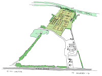
A landowner in Walton on Thames, Surrey has launched an
online consultation over plans for a grassroots football centre and camping
ground. The website, AppsFC.blogspot.com, designed by Studio 425 architect John
Inglis, invites local football clubs, schools, community groups and welfare support
networks for people living with disabilities to get involved with the design
process.
Subscribe to:
Posts (Atom)


